Friday, 16 June 2017

PAURI RAMLELA "GOLDEN 100 YEARS"


The Pauri Ramlila is one of the oldest plays in the Uttarakhand region. It portrays the life of Lord Rama as described in Ramayana. The play was begun by two social activists, Tara Dutt Gairola and Bhola Dutt Kala, in 1883-1884.
At that time, Pauri was the administrative capital of East India Company in the Garhwal Region. Gairola and Kala organized the Ramlila and played it with the help of locals for six days at the sloppy fields of village Kandai. During the period, some other literary persons joined the play and modified it into "Persian Theater". They made the script with the help of Tulsi Das's Ramcharitmanas and some of their own interpretations. In 1906, the play was expanded from six days to ten days.
The play has been performed until 1993, but was interrupted during the Uttarakhand movement from 1994 until 1996. In 1997, it was restarted following an initiative by Prithvi Pal Singh Chauhan, the M.L.C. of U.P.

Thursday, 15 June 2017

HISTORY OF DHERADUN


In Skanda Purana, Dun is mentioned as a part of the region called Kedar Khand, the abode of Shiva. In ancient India during the Mahabharata epic era, Dronacharya the great teacher of Kauravas and Pandavas lived here hence the name, "Drona-nagri".[3]
A rock edict of Ashoka, the legendary Mauryan King, who ruled between 273 BC to 232 BC., was discovered at Kalsi, 56 km. from Dehradun, by John Forest, in 1860.[4][5]

According to history of Dehradun it has been part of Garhwal kingdom except for brief interlude of rohillas. The present town of Dehradun was named after 'Guru Ram Rai', the elder son of seventh Sikh Guru, Guru Har Rai, who was part of the Udasi sect of Sikh Asceticism,[6] who came here in 1675, and first settled in village 'Dhamawala', which even today hosts the annual 'Jhanda Fair' on the fifth day after Holi in his memory.[7] Thus the name refers to his Dera or settlement in the valley, around which the present town gradually developed,[8] and marking this settlement is a Gurudwara called 'Guru Ram Rai Darbar', built in 1699 with the help of Raja of Garhwal, Fateh Shah, who was succeeded by his grandson in the same year, Pratap Shah,[1] and modelled on the tomb of Mughal Emperor Jehangir.[9]
Dehradun was an part of Garhwal kingdom, then after it was a part of gurka kingdom for 12 years. Gurkhas lost Dehradun to England when India was colonized by England. Historically, Dehradun has remained part of the Garhwal Kingdom also known as 'Kedarkhand', which was founded by Ajai Pal, around 1400, by capturing all the minor principalities of the Garhwal region, under his own sway, and thereafter, he and his descendants ruled over Garhwal and the adjacent state of Tehri-Garhwal, in an uninterrupted line till 1803, when Gurkhas invaded Kumaon and Garhwal.[10]
In between, until Najib-ul-Daula, the governor of Saharanpur, who later founded city of Najibabad, invaded the city with his army of Rohillas in 1757, and ruled here, leading to its widespread development, though after his death in 1770, it was successively annexed by surrounding tribes of Rajputs, Gujjars, Sikhs and Gurkhas who ruled the region in quick succession, and lead to its steady downfall.
Finally in 1803, it was annexed by the Gurkhas, who made the king of Garhwal, Pradyuman Shah, flee to Saharanpur, leaving the region to be ruled by an iron fist by the Gurkha general 'BAL BHADRA THAPA'. Later, King Pradyumna Shah and his sons Kuwar Parakrama Shah and Kuwar Pritam Shah, and a 12,000 strong army fought with the Gorkhas at Khurhbure, where the king was killed.
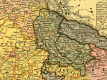
Dehradun as a part of United Provinces, 1903.
In the same year, the British had already taken over Saharanpur, which lead to continuous skirmishes between the two armies, leading to the Gurkha War (1814–1816), also known as the Anglo-Nepalese War, when eventually the Gurkhas were ousted after the siege of the fort of Nalapani.
The Sugauli Treaty, signed on 2 December 1815 and ratified by 4 March 1816, between the British East India Company and The Kingdom of Nepal, ending the second British invasion of the Himalayan kingdom during the Anglo-Nepalese War (1814–1816). The signatory for Nepal was Raj Guru Gajaraj Mishra aided by Chandra Sekher Upadhyaya and Lieutenant-Colonel Paris Bradshaw signed for the Company.
The treaty led to the annexation of the Dehradun and east Garhwal Kingdom into the British Empire, and they became part of the Garhwal District, in the Kumaon Division of the United Provinces, and had an area of 5629 sq. mi, and that is when it slowly started regaining its lost glory.[2][11][12] Meanwhile, the west Garhwal was reinstituted to the Garhwal Kingdom, and Sudarshan Shah, son of slain king, was made the king of Tehri Garhwal, who made Tehri his capital.
'Dehra Dun' municipality was established in 1867, and in 1900 railways made its way to Dehradun via Haridwar, which was earlier connected in 1886.[13]
In 1901, Dehradun had a population of 24,039,[9] and was a district of British India, in the Meerut division of the United Provinces,[2] while the neighbouring town of Rajpur, which lay en route to the hill-station of Mussourie, and from where pure-drinking water was supplied to the city through pipes, had a population of 2,900.[14]
During the Second World War the Dehra Dun Central Internment Camp was a major prison camp for detained German, Austrian and Italians who were living in or visiting British colonies in Asia at the start of the war.[15] Its most famous inmate was perhaps Heinrich Harrer, who after several attempts finally escaped in 1944 with Peter Aufschnaiter and slipped over the mountains into neutral Tibet. He recounted his time at the camp in Seven years in Tibet (Rupert Hart-Davis, 1953) and Beyond seven years in Tibet: my life before, during and after. (Labyrinth Press, 2007). Several German Buddhist monks, including Nyanatiloka, also stayed here. The camp was divided into different sections, one for Germans loyal to the Nazi government, one for German communists and others who rejected the Nazi government, one for Italians, and one section for Italian Catholic clergy.[16]

kandoliya


Wednesday, 14 June 2017

HISTORY OF PAURI GARHWAL


The evolution of human civilization in this region of Garhwal Himalaya has paralleled that of the rest of the Indian sub-continent. The earliest historical dynasties were the Kunindas (before the 6th century A.D.) and the Katyuris (6th to 12th century A.D.), which ruled over unified Uttarakhand and left important records in the form of temples and inscriptions. After the downfall of the Katyuris, it is believed that the Garhwal region was fragmented into more than sixty-four principalities ruled by chieftains, one of the principal chieftainships being that of Chandpurgarh. In the middle of the 15th century A.D., Chandpurgarh emerged as a powerful principality under the rule of King Jagatpal (1455 to 1493 A.D.), who was a descendent of Kanakpal. Toward the end of 15th century A.D., King Ajaypal of Chandpurgarh ruled the entire region. Subsequently, his kingdom came to be known as Garhwal and he transferred his capital from Chandpur to Devalgarh before 1506 A.D. and later to Srinagar between 1506 and 1519 A.D.[1][2]
King Ajaypal and his successors, the Pal (Shah) dynasty, ruled Garhwal for nearly three hundred years. During this period they faced a number of attacks from Kumaon, Mughals, Sikhs, and Rohillas. An important event in the history of Pauri Garhwal district was the Gorkha invasion. This invasion was marked by extreme brutality. After conquering Doti and Kumaon, Gorkhas attacked Garhwal and met stiff resistance from the Garhwali forces. Then news came of a Chinese invasion, and the Gorkhas were forced to lift the siege. In 1803, however, the Gorkhas again mounted an invasion. After capturing Kumaon, three columns attacked Garhwal. In 1804, the Gorkhas defeated the army of King Pradyumna Shah and became the masters of all of Garhwal. They ruled the territory for twelve years.
In 1816, at the end of the Anglo-Nepalese War and the defeat of the Gorkha army, the rule of the Gorkhas in Garhwal was ended by the British. On 21 April 1815, the British decided to establish their rule over the eastern half of Garhwal, lying east of the Alaknanda and Mandakini rivers. The remaining part of Garhwal in the west was returned to King Sudarshan Shah who established his capital at Tehri. Initially the administration was entrusted to the commissioner of Kumaon Division, with headquarters at Almora, but later, in 1837, Garhwal was separated and formed into a separate district under an assistant commissioner with his headquarters at Pauri.


panch badri

:: PANCH BADRI YATRA UTTARAKHAND ::
The five Badries are revered by all as the apt tribute to Lord Vishnu. Badrinath is devoted to the worship of Vishnu who, according to an amusing tale, usurped this place from Shiva. For Vishnu had come here as the gods once did, to offer penance. He loved the place so much that he plotted to unseat Shiva from his meditation here. He took on the form of a beautiful child and began to wail. Shiva's wife, Parvati picked him up but could not calm the child. Since his wailing continued to disturb Shiva, he shifted to Kedarnath in exasperation, leaving the spot free for Vishnu to occupy. But remainders of Shiva's stay continue to linger, most visibly in the name, Badri, a kind of berry that Shiva was most fond of, and the gigantic tree, invisible to the morale eye, that served Shiva. Considered one of the Char Dgam or four principle places of Hindu worship at Himalayas, Badrinath four subsidiary Badries include Bhavishya Badri, Yogdhyan Badri, Vridha Badri and Adi Badri.

Badrinath

Also known as Vishal Badri, this temple located at the height of 3,133 mts. is the largest Himalayas and most popular of Vishnu pilgrimages among the five Badries. The original temple here is believed to be built by King Pururava and the icon of the lord carved by Vishwakarma, the creator of the gods. The idol was recovered by Adi Shankaracharya from the waters of the nearby  Naradkund and consecrated once more in the temple, restored in the 19th century by the royal houses of Scindia & Holker. So holy in this shrines that it forms one of the four prominent places of Hindu worship. The epic Mahabharata, it is believed, was composed in the Vyas and Ganesh caves close by. The Vishnu Ganga which later becomes Alaknanda flows below the while Neelkanth keeps vigil over all devotees.

Bhavishya Badri

The Future Badri is located at 2,744 mts. amidst the thick forests surrounding Tapovan. According to a divination, it is here that all devotees will throng once Badrinath is no more. While there can be no conceivable reason why this should happen, scientists agree that Joshimath, the entry point into the area before the final, most strenuous climb, is sited on an ancient landslide and has been sinking, and with a barrage coming up close by, may actually see the fulfillment of the divine prophecy.
But whatever happens, Bhavishya Badri is popular even now. Enshrined here is the lion headed image of Narsingh. Visitors pass the serene the Tapovan a place known for its hot water springs en route to the banks of the Dhauliganga, and on to shrine.

Yogdhyan Badri

Every so often in the Garhwal Himalayan, tales from the Mahabharatha spring magically to life. Yogdhyan Badri, 1,920 mts. is located at Pandkeshawar, named after the Pandavas King. It is said that the Pandavas, victorious after their battle against the Kauravas, but emotionally scarred, came to the Himalaya.
And it was here that they handed over their capital, Hastinapur, to Raja Prikshit and took up penance before seeking out the highway to heaven. The importance of the Badri is immense and the sanctum has an image of the lord in a meditative postures.

Virdha Badri

Before Badrinath was designated one of the four Char Dham of Hindu worship by Adi Shankaracharya, the idol of Badrinath carved by divine Vishwakarma was enshrined and worshipped here. It is said that when mankind entered the age of Kali, Vishnu chose to remove himself from the temple. Interestingly the image was found by Adi Shankaracharya at NaradKund, and restored, through part of it remains damaged. This, the first Badri, is located at the height of 1,380 mts. at Animath. While Badrinath closes during winter, the idol and priests hibernating at Joshimath, Virdha Badri remains opens throughout the years.

Adi Badri

Another pilgrimage centre of local importance is this group of 16 temples en route to Ranikhet and closes to the confluences at Karan Prayag. The main temple is dedicated to Narayan and has a raised platform in the pyramidal form. Within the temple, a black stone idolis installed.
It is believed that these temples, dating to the Gupta age , was sanctioned by Adi Sankaracharya who wanted to spread the tenants of Hinduism to every remote corner of the country. 

Tuesday, 13 June 2017

gauri khund


Gauri Kund is a Hindu pilgrimage site and base camp for trek to Kedarnath Temple, in Uttarakhand , India.[1][2] It is situated at an altitude of 18,200 feet above mean sea level in the Garhwal Himalayas.It is the second highest lake in the world after Tso Sekuru which is located at the height of 18,284 feet above mean sea level(Tibetan Plateau). Gauri Kund is connected with Shiva's wife Parvati, also known as Gauri. In Hindu folklore, Gauri committed to penance involving many ascetic and yogic practices to win over Shiva's affections. Local tradition claims that Gauri Kund is the spot where Gauri lived while carrying out these practices and it was here that Shiva finally admitted His love for Her. They were married at Triyugi Narayan, which is located nearby. There are hot springs in Gaurikund and they are converted to bathing places. This place is also associated with the legend of how Ganesha acquired his elephant head. While bathing in the kund, Goddess Parvati fashioned Ganesha from the soap suds on Her body, breathed life into Him and placed Him at the entrance as Her guard. Lord Shiva happened to arrive at the spot and He was stopped by Ganesha. Indignant at this affront, Shiva cut off Ganesha's head and Parvati was inconsolable. She insisted that the boy be brought back to life and Shiva took the head of a wandering elephant and placed it on Ganesha's body. Parvati had Her son back and Ganesha acquired the persona by which He is known all over the Hindu world since then.

Tuesday, 6 June 2017

yamunotri


Yamunotri (Hindi: यमुनोत्री) is the source of the Yamuna River and the seat of the Goddess Yamuna in Hinduism. It is situated at an altitude of 3,293 metres (10,804 ft) in the Garhwal Himalayas and located approximately 30 kilometers (19 mi) North of Uttarkashi, the headquarters of the Uttarkashi district in the Garhwal Division of Uttarakhand, India. It is one of the four sites in India's Chhota Char Dham pilgrimage. The sacred shrine of Yamunotri, source of the river Yamuna, is the westernmost shrine in the Garhwal Himalayas, perched atop a flank of Bandar Poonch Parvat. The chief attraction at Yamunotri is the temple devoted to the Goddess Yamuna and the holy thermal springs at Janki Chatti (7 km. Away). The actual source, a frozen lake of ice and glacier (Champasar Glacier) located on the Kalind Mountain at a height of 4,421 m above sea level, about 1 km further up, is not frequented generally as it is not accessible; hence the shrine has been located on the foot of the hill. The approach is extremely difficult and pilgrims therefore offer puja at the temple itself. The temple of Yamuna, on the left bank of the Yamuna, was constructed by Maharaja Pratap Shah of Tehri Garhwal. The deity is made of black marble. The Yamuna, like the Ganges, has been elevated to the status of a divine mother for the Hindus and has been held responsible for nurturing and developing the Indian civilization. Close to the temple are hot water springs gushing out from the mountain cavities. Surya Kund is the most important kund. Near the Surya Kund there is a shila called Divya Shila, which is worshipped before puja is offered to the deity. Devotees prepare rice and potatoes, tied in muslin cloth, to offer at the shrine by dipping them in these hot water springs. Rice so cooked is taken back home as prasadam. The pujaris of Yamunotri come from the village of Kharsali near Janki Chatti. They are the administrators of the sacred place and perform religious rites. They are well-versed in the Shastras. Contents [hide] 1 History and legends 2 Geography 3 Yamuna River 4 Yamunotri Temple 5 Timings 6 See also 7 References History and legends[edit] Yamunotri as depicted by James Baillie Fraser (1820) According to the ancient legend, sage Asit Muni had his hermitage here. All his life, he bathed daily both in the Ganges and the Yamuna. Unable to go to Gangotri during his old age, a stream of the Ganges appeared opposite Yamunotri for him. The temple and the place opens every year on the auspicious day of the Akshaya Tritya, which generally falls during the last week of April, or the first week of May. The temple always closes on the sacred day of Diwali in mid-October - first week of November, with a brief ceremony. The temple staff return to their villages and for the rest of the time the valley is gripped in no-man silence and covered with a white sheet of snow. With the melting of the snow next summer, the temple re-opens. Sangya is the birthplace of the Yamuna in the Champasar Glacier (4,421 m) just below the Banderpoonch Mountain. The mountain adjacent to the river source is dedicated to her father, and is called Kalind Parvat, Kalind being another name of Surya. Yamuna is known for her frivolousness, a trait that she developed because, according to a common story, Yamuna's mother could never make eye contact with her dazzling husband. Geography[edit] Yamunotri is located at 31.01°N 78.45°E.[1] It has an average elevation of 3,954 metres (12,972 ft). Yamuna River[edit] Main article: Yamuna River The actual source of Yamuna River lies in the Yamunotri Glacier, at a height 6,387 metres (20,955 ft), near the Bandarpunch peaks in the Lower Himalayas and is dedicated to goddess Yamuna.[2] It crosses the states of Uttarakhand, Haryana, Uttar Pradesh, Himachal Pradesh and later Delhi before merging with the Ganges at Triveni Sangam, Allahabad. Yamunotri Temple[edit] Main article: Yamunotri Temple Yamunotri Temple is situated in the western region of Garhwal Himalayas at an altitude of 3,235 metres (10,614 ft) near the river source.[3] The original temple was built by Maharani Guleria of Jaipur in the 19th century. The current temple is of recent origin as earlier constructions have been destroyed by weather and the elements. There seems to be a confusion as to who built the temple of Yamunotri. However, according to sources, the temple was originally constructed by Maharaja Pratap Shah of Tehri Garhwal. Timings[edit] Opening hours: 6 am – 8 pm; 1st week of May - Till Diwali (October) Aarti time: 6:30 pm – 7:30 pm
Shop Amazon Devices: Echo Father's day deals starting at $39.99 Baby Registry - $100 credit towards diapers and wipes

Himalayan monal

The  Himalayan monal  ( Lophophorus impejanus ), also known as the  Impeyan monal ,  Impeyan pheasant , is a  bird  in the  pheasant f...